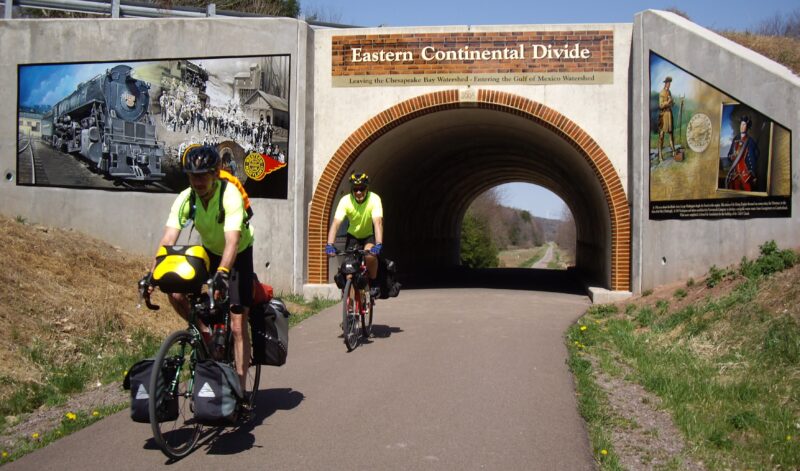
Eastern Continental Divide
somerset | Meyersdale, PA Mile 23.7
It’s all downhill from here–
The Eastern Continental Divide (ECD) is the highest point on the Great Allegheny Passage (GAP) at 2,392 feet above sea level, located at mile marker 23.7.
The watershed divide on the GAP has been intriguing trail users since the trail was opened. Pour water on one side and it flows to the Chesapeake and the Atlantic Ocean. Pour on the other side, it’s headed to the Mississippi and the Gulf of Mexico.
Importantly, it’s all downhill from here! Well, downhill to Pittsburgh and Cumberland.
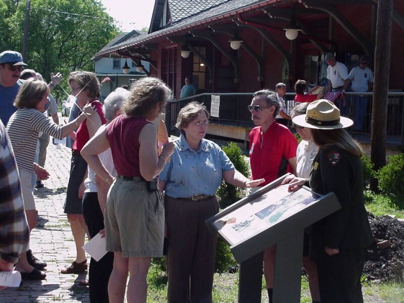
Sandra Funley with NPS officials.
In spring of 2008, the Progress Fund through Southwestern Pennsylvania Heritage Project offered funding for interpretation on the Great Allegheny.
This was a chance to do a major interpretation of the Eastern Continental Divide. A mural! The concrete overpass carrying McKenzie Hollow Road over the GAP provided the canvas.
Sandra Finley of Teeter Associates managed the project.
She contacted organizations that had commissioned murals (after checking them out on the internet) including Lincoln Highway and Sprout Fund to find artists that might be appropriate for the project. We worked with Somerset Rails to Trails and Somerset Recreation Board via Brett Hollern to determine Somerset’s preferences for the project.
Wayne Fettro who had done murals for the Lincoln Highway was the favorite artist of those we researched. He was interested and we met him in July at the site. (Linda Boxx, Brett Hollern, Jim Shaulis, Wayne and Sandra Finley).
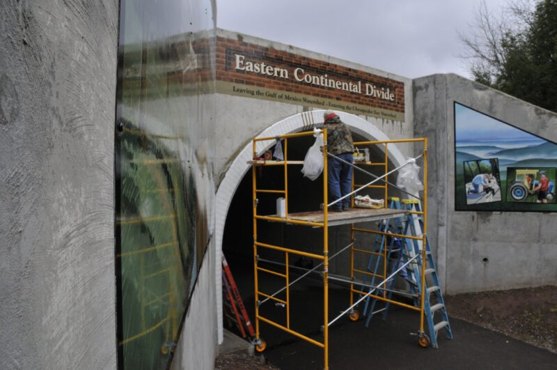
Wayne Fettro painting murals on the ECD.
Brett expressed theconcern of the Somerset groups that they didn’t want to end up with a mural that would fade, or be vandalized.
Wayne proposed doing the murals on metal (aluminum panels) in his studio at home and then attacking them to the walls of the culvert/tunnel. That was acceptable to Brett. Wayne felt he could do the project but could not complete it until this spring (09).
We then worked on getting the vision of the mural. It was determined that we would use the mural as a welcome to the different watersheds—going to Pittsburgh and the Mississippi Watershed there would be images of the history of this region—trains, coal, George Washington. Going to DC and the Chesapeake Watershed, the C&O and volunteers.
Linda McKenna Boxx suggested painting faux brick on the face of the culvert underpass to match up with the tunnels on the C&O. That was the only thing painted onto the surface and Somerset County concurred.
Eastern Continental Divide
In April 2009, Wayne installed the panels and painted the faux brick.
The work has been very well received.
In the beginning, there was a concern is that the elevation chart inside the culvert seems to exaggerate the gradient. There was some talk of having it redone—stretched out. However, it seems the chart is very popular with trail users—and it’s become a popular photo op.
For more information visit:
https://en.wikipedia.org/wiki/Eastern_Continental_Divide
Author: Sandra Finley